Directory and moreAll AntiquesFurnitureSilverArtJewellerySalvageClocksMirrorsChairsGlassCeramicsDirectory and moreBedsBookcasesCabinetsChairsChest of DrawersCupboardsDesksDressersDressing TablesSideboardsStoolsTablesWardrobesBasketsBowlsBoxesCandlesticksCard HoldersCoastersCoffee PotsCondimentsCutleryDecanter LabelsDishesSpoonsVasesCityscape ArtContemporary ArtDrawingsEaselsLandscape ArtMarinescape ArtMiniaturesOil PaintingsPastelPortraitsSeascape ArtStill LifeWatercoloursAntique Bracelets & BanglesBroochesCufflinksDiamond RingsEarringsEngagement & Wedding RingsJewellery BoxesLocketsNecklacesPendantsRingsSets - Demi ParureSolitaire RingsBathsChimneysColumnsDoor Handles / Door Stops / Door KnockersDoorsFireplacesFlooringIndustrial antiquesLocks / KeysReclaimed & Industrial LightingReclamationWindowsBracket ClocksCarriage ClocksClock SetsCuckoo ClocksDial ClocksFusee ClocksGrandfather ClocksLongcase ClocksMantel ClocksPocket WatchesSkeleton ClocksWall ClocksWatchesConvex MirrorsDressing MirrorsDressing Table MirrorsFrench MirrorsGilt MirrorsLarge MirrorsOval MirrorsOvermantle MirrorsPier MirrorsSwing MirrorsToilet MirrorsVictorian MirrorsWall MirrorsArmchairsClub ChairsCorner ChairsCountry ChairsDesk ChairsDining ChairsHall ChairsKitchen ChairsLibrary ChairsOffice ChairsPair of ChairsRocking ChairsWing ChairsAntique Drinking GlassesChampagne GlassesDecantersEpergnesGlass BowlsGlass CruetGlass DishesGlass InkwellGlass JugsGlass SculpturesGlass VasesScent BottlesTantalusAnimal FigurinesBlue and WhiteBowlsChargersChinaCoffee Pots & SetsDinner ServiceDishesFigurinesJugsTea Pots and SetsVases (Ceramic)Business DirectoryLoveAntiques DealersHome & LivingBlogMaterialsPeriodsArtisansOriginsGifts For HimGifts For Her

London Fine Ltd

We are a team passionate about antiques and customer service. With trade and private clients worldwide we offer a complete sourcing, restoration and delivery network. From order to delivery our focus is on customer service.
Buy with Confidence Guarantee
We offer a 100% Total Satisfaction Guarantee: Every item we sell is covered by our Total Satisfaction Guarantee: If, within 14 days of receipt, you are unsatisfied with the item it may be returned for a full refund. Our business is nothing without customer service. Simply pack it up safely and return it to our address and we will provide a refund of the purchase price upon receipt.
Address
The Antique Village, The Old Whiteways Cider Factory
Hele
Devon
United Kingdom
EX5 4PW
Opening times
10am - 4pm, Monday to Saturday
Phone
+442071 833511
LoveAntiques Dealersince May 2017Approved item3359 sales by dealerFree DeliveryAvailable for local pick-up
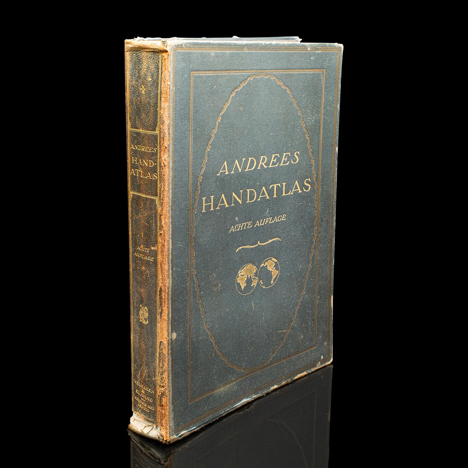
Antique Andrees Handatlas, German Cartography Book, Maps, Atlas, Reference, 1924
REF: 25252 / LA525578
£395
€450
$527
Secure Payments By
LoveAntiques Dealersince May 2017Approved item3359 sales by dealerFree DeliveryAvailable for local pick-up
Description
This is a large volume antique copy of Andrees' Handatlas. A German, bound chromolithography atlas, dating to the early 20th century, this edition published in 1924.
Full title: Andrees Allgemeiner Handatlas in 228 Haupt - und 215 Nebenkarten mit vollständigem alphabetischen Namenverzeichnis in besonderem Bande.
Superb cartographic detail to this comprehensive, fine bound atlas. Displays a desirable aged patina and in lightly time worn, intact order. Large proportion, making for ease of studying the full colour maps. Bound in cloth on board with gold titling to cover and spine. Presented in German across 228 main maps and 215 excerpts.
This is a fascinating large volume antique copy of Andrees' Handatlas, with delightful early 20th century cartographic detail, in full colour and with comprehensive coverage of the Earth in period. Delivered ready to enjoy.
We offer a 100% satisfaction guarantee with all of our antiques.
Please contact us if you require any further information - we are here to help.
measurements
Height:
45 cm
Width:
30.5 cm
Depth:
6.5 cm
declaration
London Fine Ltd has clarified that the Antique Andrees Handatlas, German Cartography Book, Maps, Atlas, Reference, 1924 (LA525578) is genuinely of the period declared with the date/period of manufacture being c.1920
condition
Presented in good, intact antique condition.
additional info
Material:
Date of Manufacture:
c.1920
location
This Antique Andrees Handatlas, German Cartography Book, Maps, Atlas, Reference, 1924 is located in Devon, United Kingdom
Share:
A selection of items from London Fine Ltd
London Fine Ltd has 1595 items available.£ 1,495
€1,702
$1,995
Antique Turner's Chair, English Oak, Warwick, Old Saxon, Elbow Seat, Victorian
£ 1,495
€1702
$1995
London Fine Ltd
£ 1,275
€1,451
$1,701
Antique Morning Room Chair, English, Desk, Elbow Seat, Sheraton Taste, Georgian
£ 1,275
€1451
$1701
London Fine Ltd
£ 695
€791
$927
Antique Campaign Tea Table, Anglo-indian, Carved, Lamp, Side, Victorian, C.1900
£ 695
€791
$927
London Fine Ltd
£ 1,595
€1,816
$2,128
Antique Turner's Chair, English, Oak, Old Saxon, Elbow Seat, Victorian, C.1900
£ 1,595
€1816
$2128
London Fine Ltd
£ 2,850
€3,244
$3,803
Antique Bachelor's Chest of Drawers, English, Master Bedroom Tallboy, Georgian
£ 2,850
€3244
$3803
London Fine Ltd
£ 1,175
€1,338
$1,568
Antique Morning Room Chair, English, Desk, Elbow Seat, Reception Hall - Regency
£ 1,175
€1338
$1568
London Fine Ltd


