Directory and moreAll AntiquesFurnitureSilverArtJewellerySalvageClocksMirrorsChairsGlassCeramicsDirectory and moreBedsBookcasesCabinetsChairsChest of DrawersCupboardsDesksDressersDressing TablesSideboardsStoolsTablesWardrobesBasketsBowlsBoxesCandlesticksCard HoldersCoastersCoffee PotsCondimentsCutleryDecanter LabelsDishesSpoonsVasesCityscape ArtContemporary ArtDrawingsEaselsLandscape ArtMarinescape ArtMiniaturesOil PaintingsPastelPortraitsSeascape ArtStill LifeWatercoloursAntique Bracelets & BanglesBroochesCufflinksDiamond RingsEarringsEngagement & Wedding RingsJewellery BoxesLocketsNecklacesPendantsRingsSets - Demi ParureSolitaire RingsBathsChimneysColumnsDoor Handles / Door Stops / Door KnockersDoorsFireplacesFlooringIndustrial antiquesLocks / KeysReclaimed & Industrial LightingReclamationWindowsBracket ClocksCarriage ClocksClock SetsCuckoo ClocksDial ClocksFusee ClocksGrandfather ClocksLongcase ClocksMantel ClocksPocket WatchesSkeleton ClocksWall ClocksWatchesConvex MirrorsDressing MirrorsDressing Table MirrorsFrench MirrorsGilt MirrorsLarge MirrorsOval MirrorsOvermantle MirrorsPier MirrorsSwing MirrorsToilet MirrorsVictorian MirrorsWall MirrorsArmchairsClub ChairsCorner ChairsCountry ChairsDesk ChairsDining ChairsHall ChairsKitchen ChairsLibrary ChairsOffice ChairsPair of ChairsRocking ChairsWing ChairsAntique Drinking GlassesChampagne GlassesDecantersEpergnesGlass BowlsGlass CruetGlass DishesGlass InkwellGlass JugsGlass SculpturesGlass VasesScent BottlesTantalusAnimal FigurinesBlue and WhiteBowlsChargersChinaCoffee Pots & SetsDinner ServiceDishesFigurinesJugsTea Pots and SetsVases (Ceramic)Business DirectoryLoveAntiques DealersHome & LivingBlogMaterialsPeriodsArtisansOriginsGifts For HimGifts For Her

Art & Stuff

I specialise in affordable original artworks - mainly traditional watercolours and oil paintings but I also have a range of contemporary artworks including limited edition lithographic prints. I also stock a limited selection of antiques and collectables, including treen, ceramics and glass. I have now opened a shop at 26 High St Wallingford (OX100BU) between Reading and Oxford, but I also trade online. My website, www.artandstuffgallery.com has a gallery section with several mini-galleries where my items are displayed, including more contemporary items not shown on LoveAntiques.
Address
Art & Stuff
Wallingford
Oxfordshire
United Kingdom
OX10 0BU
Directions
Directly opposite The George Hotel
Opening times
Friday & Saturday 11am to 4.30 pm ish. Sunday 12pm to 4pm
Mobile
+447415 855890
LoveAntiques Dealersince Jul 2016Approved item846 sales by dealerFree DeliveryAvailable for local pick-up
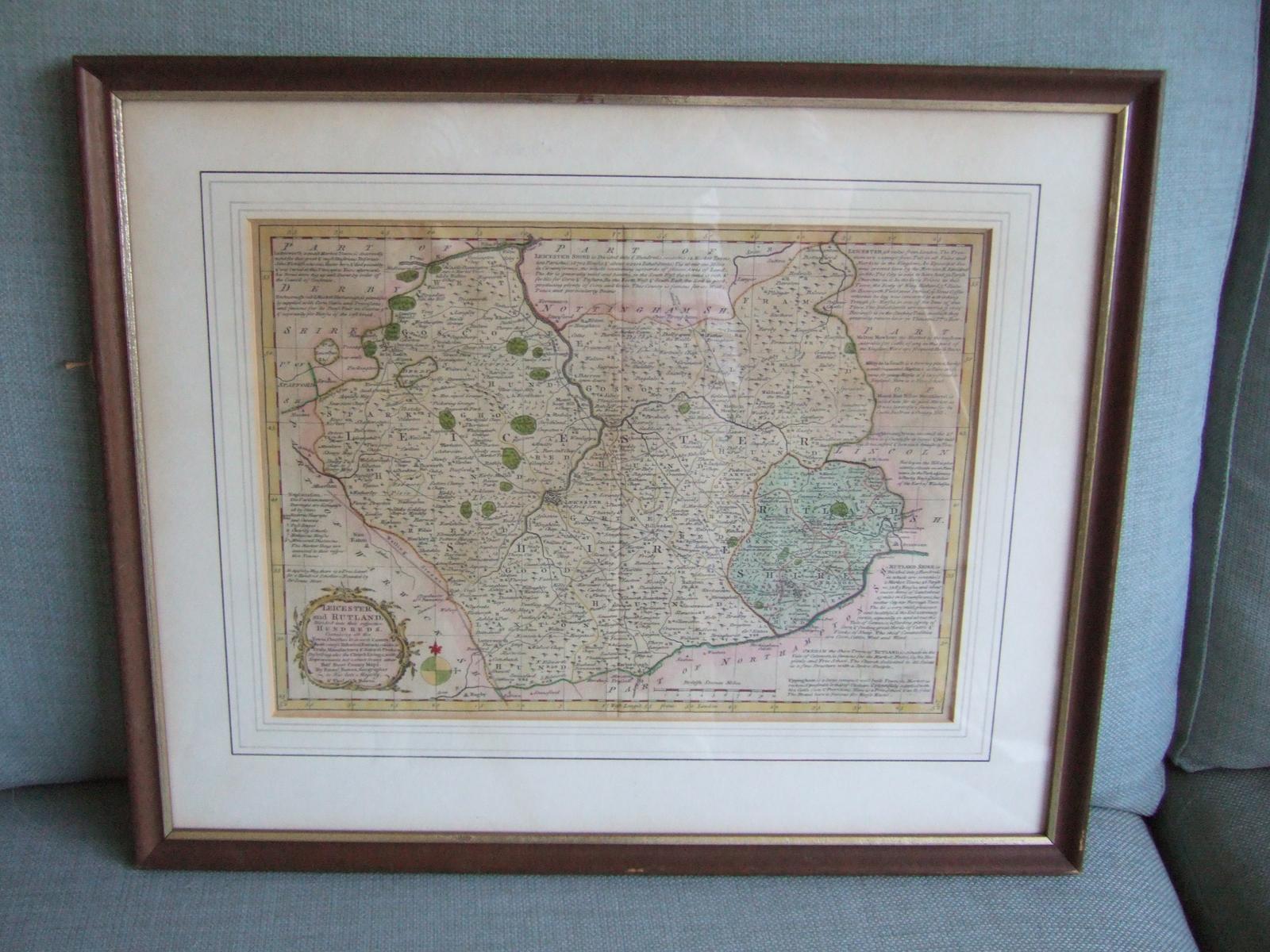
Mid 18th Century Map of Leicestershire & Rutland by Bowen
REF: P2346 / LA462674
£85
€97
$113
Secure Payments By
LoveAntiques Dealersince Jul 2016Approved item846 sales by dealerFree DeliveryAvailable for local pick-up
Description
Antique map of Leicestershire and Rutland, ca. 1760 by Emanuel and Thomas Bowen, who were a prominent father/son duo of cartographers. Emanuel was appointed as Mapmaker to George II (and also, uniquely to Louis XV of France) and produced a number of important maps and atlases during his career, including a series of county maps of England and Wales. Emmanuel and Thomas Bowen are known for their accurate and detailed maps, which were highly sought after by collectors and scholars of the time. This map is believed to have come from "Atlas Anglicanus", published in 1767. It is richly detailed and has descriptive text describing the major towns and cities of the county.
measurements
Height:
38 cm
Width:
46 cm
declaration
Art & Stuff has clarified that the Mid 18th Century Map of Leicestershire & Rutland by Bowen (LA462674) is genuinely of the period declared with the date/period of manufacture being ca.1767
condition
Crease to centre where it has come out of a book. Otherwise excellent. Presented in a stained wooden frame with gilding to inner edge.
additional info
Category:
Material:
Date of Manufacture:
ca.1767
location
This Mid 18th Century Map of Leicestershire & Rutland by Bowen is located in Oxfordshire, United Kingdom
Share:
A selection of items from Art & Stuff
Art & Stuff has 147 items available.£ 130
€148
$173
Art & Stuff
Lalique Glass Pin Dish in Form of a Dove
£ 135
€154
$180
Art & Stuff
Saxton & Hole: Map of Oxfordshire ca.1637
£ 145
€165
$193
£ 48
€55
$64
Art & Stuff
Sunderland Lustre Ware Jug
£ 125
€142
$167
Art & Stuff
Phil Greenwood (b.1943): Etching "Tree Net"
£ 165
€188
$220


