Directory and moreAll AntiquesFurnitureSilverArtJewellerySalvageClocksMirrorsChairsGlassCeramicsDirectory and moreBedsBookcasesCabinetsChairsChest of DrawersCupboardsDesksDressersDressing TablesSideboardsStoolsTablesWardrobesBasketsBowlsBoxesCandlesticksCard HoldersCoastersCoffee PotsCondimentsCutleryDecanter LabelsDishesSpoonsVasesCityscape ArtContemporary ArtDrawingsEaselsLandscape ArtMarinescape ArtMiniaturesOil PaintingsPastelPortraitsSeascape ArtStill LifeWatercoloursAntique Bracelets & BanglesBroochesCufflinksDiamond RingsEarringsEngagement & Wedding RingsJewellery BoxesLocketsNecklacesPendantsRingsSets - Demi ParureSolitaire RingsBathsChimneysColumnsDoor Handles / Door Stops / Door KnockersDoorsFireplacesFlooringIndustrial antiquesLocks / KeysReclaimed & Industrial LightingReclamationWindowsBracket ClocksCarriage ClocksClock SetsCuckoo ClocksDial ClocksFusee ClocksGrandfather ClocksLongcase ClocksMantel ClocksPocket WatchesSkeleton ClocksWall ClocksWatchesConvex MirrorsDressing MirrorsDressing Table MirrorsFrench MirrorsGilt MirrorsLarge MirrorsOval MirrorsOvermantle MirrorsPier MirrorsSwing MirrorsToilet MirrorsVictorian MirrorsWall MirrorsArmchairsClub ChairsCorner ChairsCountry ChairsDesk ChairsDining ChairsHall ChairsKitchen ChairsLibrary ChairsOffice ChairsPair of ChairsRocking ChairsWing ChairsAntique Drinking GlassesChampagne GlassesDecantersEpergnesGlass BowlsGlass CruetGlass DishesGlass InkwellGlass JugsGlass SculpturesGlass VasesScent BottlesTantalusAnimal FigurinesBlue and WhiteBowlsChargersChinaCoffee Pots & SetsDinner ServiceDishesFigurinesJugsTea Pots and SetsVases (Ceramic)Business DirectoryLoveAntiques DealersHome & LivingBlogMaterialsPeriodsArtisansOriginsGifts For HimGifts For Her

Antique and Unique

Antique and Unique is a family run business based in the Derbyshire Peak District. We love antiques, and buy and sell items that we personally like, whether it be a 17th century bible box, an Arts and Crafts table or a piece of Chinese blue and white porcelain.
Address
Unit 2, Tideswell Business Park
Tideswell
Derbyshire
United Kingdom
SK17 8PY
Opening times
Monday to Friday 10am - 5pm (it is best to call first). Saturdays by appointment.
Mobile
+447813 369871
LoveAntiques Dealersince Oct 2021Approved item383 sales by dealerFree DeliveryAvailable for local pick-up
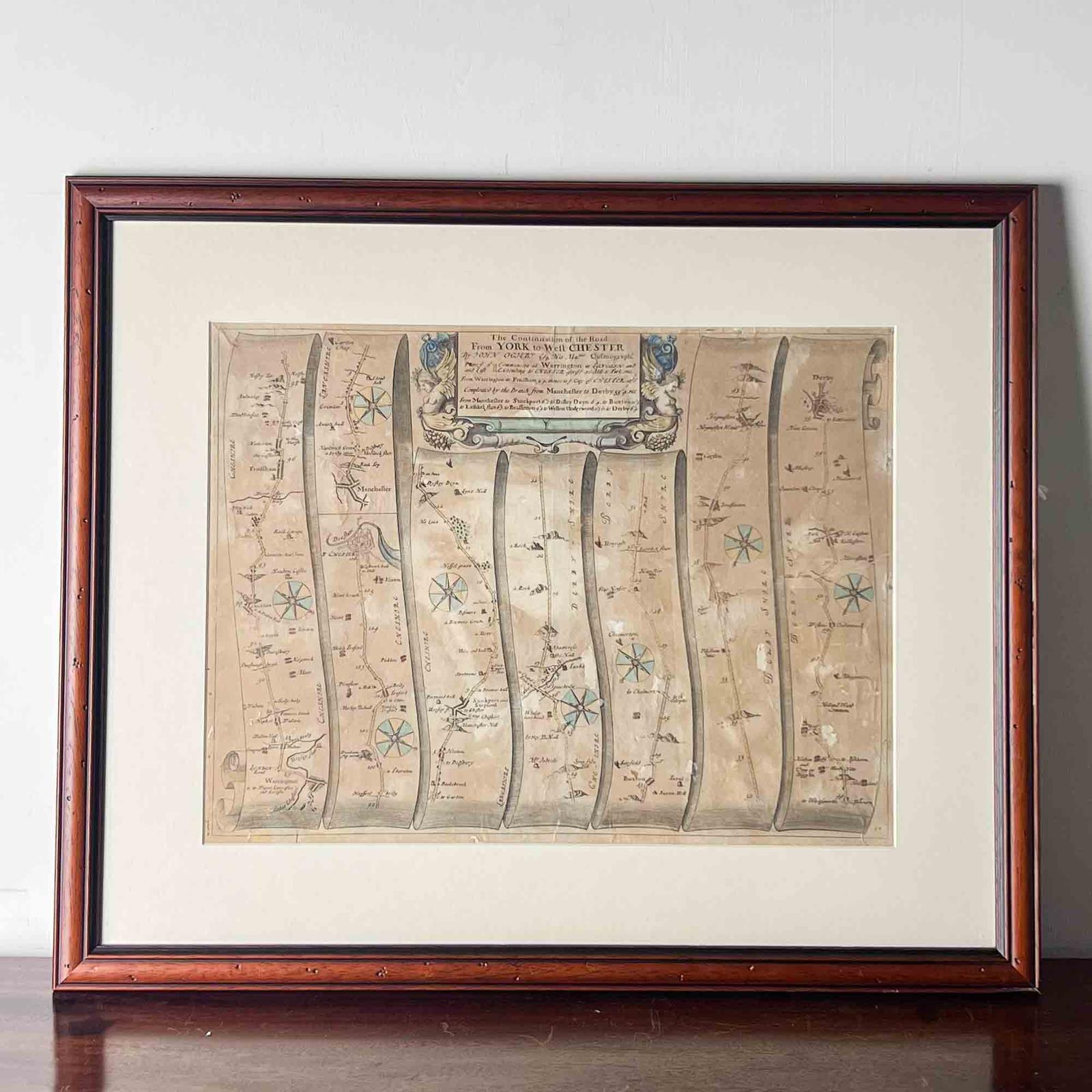
Seventeenth Century Road Map by John Ogilby
REF: LA514515
£110
€126
$147
Secure Payments By
LoveAntiques Dealersince Oct 2021Approved item383 sales by dealerFree DeliveryAvailable for local pick-up
Description
A fascinating hand coloured road map or strip map by John Ogilby, showing the route from Warrington to Derby, taken from the 1698 edition of Ogilby’s ‘Britannia’ map. The Briannia held one hundred routes, and this is plate number ninety.
John Ogilby had a fascinating life and it is well worth reading up about him. Amazingly, he didn’t start the incredible task of producing a road map of Britain until he was in his seventies. The first edition of the Britannia was published in 1675, and John sadly died the following year. The second edition was published in 1698. The maps were very popular with travellers, as it enabled them to see distances between towns clearly and therefore better plan how long their routes would take.
To read the map, start in the bottom left hand corner and move up the strip, then back to the bottom of the next one, and so on until you finish in the top right corner. It shows a route through Cheshire, briefly into Lancashire, back into Cheshire, and then into Derbyshire. There are a lot of familiar names though differing slightly with age. Being from Derbyshire, that section is of most interest to me. I especially like how on the stretch between ‘Shawcross the hall’ and Buxton, the only landmarks are two craggy area marked ‘a rock’.
A fascinating slice of history that you can easily spend a long time studying.
measurements
Height:
530 mm
Width:
640 mm
Depth:
18 mm
declaration
Antique and Unique has clarified that the Seventeenth Century Road Map by John Ogilby (LA514515) is genuinely of the period declared with the date/period of manufacture being 1698
condition
The map itself is not in very good condition and this is reflected in the price. It is heavily discoloured and has various torn areas throughout. The frame has a small area of damage on the bottom left hand corner, but is otherwise good. The map is still an attractive and interesting item despite its condition.
additional info
Period:
Category:
Material:
Date of Manufacture:
1698
location
This Seventeenth Century Road Map by John Ogilby is located in Derbyshire, United Kingdom
Share:
A selection of items from Antique and Unique
Antique and Unique has 94 items available.Antique and Unique
Cows in Woodland, Painting by Gordon Clifford Barlow
£ 195
€223
$261
Antique and Unique
Oil Painting by Gordon Clifford Barlow
£ 215
€245
$287
Antique and Unique
Georgian Oak Welsh Potboard Dresser
£ 1,425
€1,627
$1,905
Antique and Unique
Pair of 19th Century Embroidered Samplers
£ 395
€451
$528
Antique and Unique
Antique Primitive Wooden Vessel
£ 120
€137
$160
Antique and Unique
Small 18th Century Dutch Delft Plate
£ 75
€86
$100


